Following the First World War, France developed an extensive system of fortifications along its eastern borders. The system became known as the Maginot Line after André Maginot, the Minister of War who secured the funding for the main programme in 1930. In the Alps, however, fortification had a somewhat different history. France had already begun strengthening its defences against Italy in the late 1920s, and the resulting system became known as the Alpine Line, or Petit Maginot.
Today, the remains of these structures are scattered across the Alpine landscape. Many were damaged during wartime, while others are slowly being reclaimed by nature. Despite attempts to demolish or strip them after the war, many bunkers and fortifications have endured. They sit resolute and weathered, watching over the valleys below. Some are now part of the built environment, tucked beside roads or roundabouts, or even adjacent to tennis courts. Others remain isolated in the mountains, rarely visited except by chamois or the occasional hiker who might pause, uncertain whether they are looking at a military relic or simply a ruin.
The Maginot Line
France emerged from the First World War with enormous losses and a profound fear of another German invasion. Around 1.4 million French soldiers had been killed, while towns, villages and industrial areas in the north and east had suffered extensive destruction. The Treaty of Versailles imposed reparations on Germany, while French troops occupied parts of the Rhineland after the war. None of this removed the underlying fear that Germany would eventually recover and attempt another invasion.
The response was partly diplomatic and partly defensive. French military planners concluded that a permanent system of fortifications could make another invasion prohibitively difficult and give the French Army time to mobilise. The experience of the First World War had also demonstrated the extraordinary defensive power of concrete, artillery and machine guns.
France had regained Alsace and Lorraine, regions that had been fortified by Germany before 1914. The new defensive system incorporated some existing fortifications while adding an extensive network of new ouvrages, casemates, blockhouses and underground installations. The original concept was not quite the continuous wall that later popular descriptions of the Maginot Line suggest. It was a series of heavily fortified sectors concentrated where an attack was considered most likely, with weaker areas deliberately left open or covered by geography and military strategy.
The main construction programme began in 1930 following André Maginot's successful defence bill. The law of 14 January 1930 allocated 2.9 billion francs over five years for the defence of France's land frontiers. By the end of the decade, around five billion francs had been spent on the system.
Building the Alpine Line
The Alps were different. Italy under Benito Mussolini was regarded as an increasingly serious threat, particularly after Mussolini made territorial claims concerning Nice and the French Alpine border. France therefore began strengthening its Alpine defences before the main Maginot programme was approved. The first major new Alpine ouvrage was Rimplas, above the Tinée valley. Work began there in 1928, making it the first Maginot ouvrage to be put into construction anywhere in France. It was initially developed as part of the defence of Nice and became, in effect, a prototype for the later Alpine fortifications.
Construction in the Alps presented problems that simply did not exist on the plains of Lorraine. Roads had to be built before the forts could be constructed, materials hauled into remote valleys and machinery transported to high and inaccessible positions. The short Alpine construction season added another limitation. Fortifications were adapted to the terrain rather than imposed upon it, with tunnels driven into mountainsides and artillery positioned to cover valleys, roads and passes.
Defending the Alpine Passes
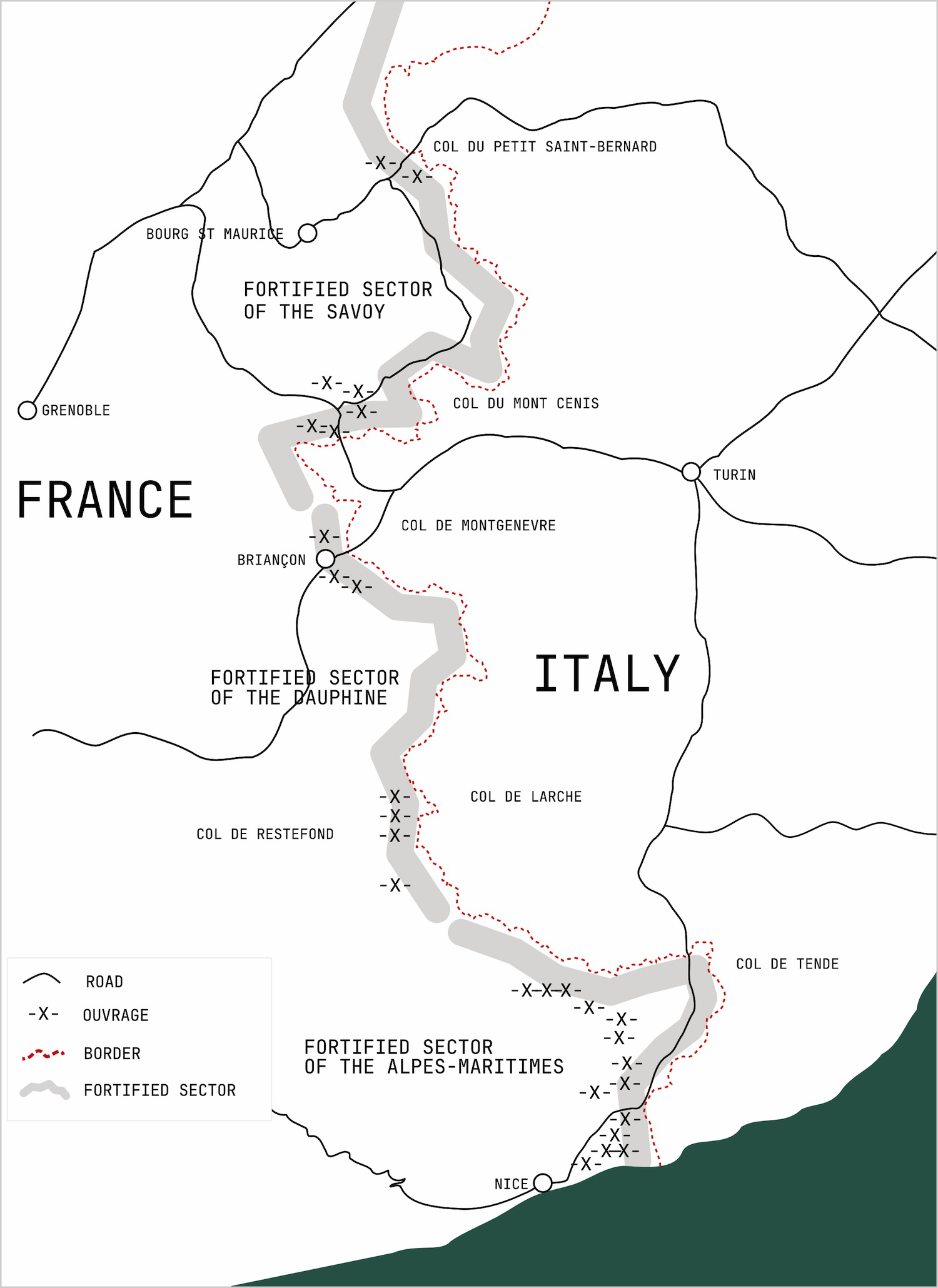
The Alpine Line was divided into three main fortified sectors: the Sector of Savoy in the north, the Sector of Dauphiné in the centre and the Sector of the Alpes-Maritimes in the south. Together they stretched from the high passes of the French-Italian frontier to the Mediterranean.
The likely routes of an Italian invasion were relatively few. By 1940, only five Alpine passes provided practical routes for motor vehicles between France and Italy: the Col du Petit-Saint-Bernard, Mont Cenis, Col de Montgenèvre, Col de Larche and Col de Tende. The rest were either unsuitable for motor traffic or depended on mountain tracks. The French fortifications were therefore concentrated around these natural corridors and the valleys leading from them.
In Savoy, the principal concerns were the approaches through the Petit-Saint-Bernard and Mont Cenis. In Dauphiné, the Col de Montgenèvre provided the most direct route towards Briançon, while the Col de Larche gave access to the Ubaye valley. Further south, the approaches to Nice and the Mediterranean coast were heavily fortified, with major ouvrages at places including Rimplas, Monte-Grosso, Sainte-Agnès, Mont Agel and Cap Martin.
Fortresses in the Mountains
The fortifications themselves ranged from small concrete blockhouses to enormous underground complexes. The larger ouvrages contained barracks, ammunition stores, power stations, ventilation systems, kitchens, communications rooms and underground galleries connecting the fighting blocks. Steel-armoured observation and weapons turrets, known as cloches, projected from the concrete roofs. In the mountains, the whole system was designed to disappear into the landscape, with only the armoured blocks and gun positions exposed.
The engineering was extraordinary. Concrete structures were designed to withstand heavy artillery bombardment, while ventilation systems protected the crews against poison gas. Some larger complexes had lifts and narrow-gauge underground railways for moving ammunition and supplies. In the Alps, however, the enormous weight of the steel armour and the difficulty of getting it into position created another problem. Some components had to be transported to isolated sites using cableways, temporary roads and other improvised methods.
The Alpine Line in 1940
By the middle of the 1930s the international situation was deteriorating rapidly. Hitler came to power in Germany in 1933, Germany reoccupied the Rhineland in 1936 and subsequently annexed Austria and occupied Czechoslovakia. The French increasingly strengthened and extended the Maginot system, while Belgium abandoned its previous military alignment with France and returned to a policy of neutrality. The French planners now had to consider the possibility that Germany might attack through Belgium, which the Maginot Line had deliberately left comparatively open.
The weakness was obvious. A fortification is only as useful as the strategy surrounding it, and the French system had been designed partly on the assumption that any German attack would be channelled towards the heavily fortified eastern frontier. In May 1940, the Germans instead attacked through the Ardennes and crossed the Meuse at Sedan, bypassing the main concentrations of the Maginot Line.
The Alpine Line faced a very different test. Italy entered the war on 10 June 1940 and attacked France along the Alpine frontier. Around 190,000 French troops under General René Olry faced a substantially larger Italian force. Despite their numerical disadvantage, the French defences held. The Italians made limited progress in some areas but failed to break through the main fortified positions. At Mont Cenis, Montgenèvre, Larche and the Petit-Saint-Bernard, the combination of terrain, fortifications and French artillery proved extremely effective.
The fighting ended with the Franco-Italian armistice on 24 June. In the Alps, the much-maligned Maginot system had done exactly what it was designed to do: it prevented the Italian Army from breaking through the mountain frontier. The great concrete fortifications were never tested in the way their designers had feared, but in the few days that mattered they proved remarkably effective.
The Alpine Line Today
Today, the Alpine Line is one of the more unusual remnants of the Second World War in the mountains. Ouvrages, casemates, observation posts and artillery positions appear throughout the valleys and high passes, sometimes hidden in apparently untouched landscapes and sometimes sitting incongruously beside modern roads. The further you travel into the Alps, the more the line reveals itself not as a single wall, but as a scattered military landscape built around the geography of the mountains themselves.