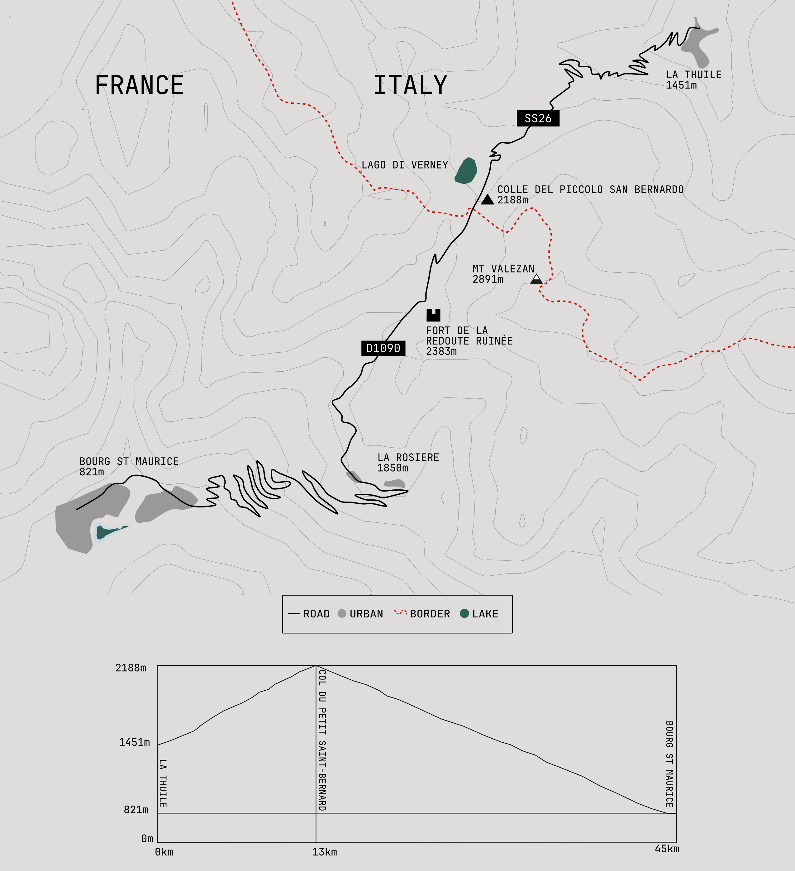
The Little St Bernard Pass is one of the oldest crossings through the western Alps, linking Italy’s Aosta Valley with France’s Tarentaise Valley. Unlike its higher and more famous neighbour, the Great St Bernard Pass, this route has always been less about altitude and more about connection, providing a natural corridor between two valleys and two countries.
The pass has been associated with Bernard of Menthon, the eleventh century archdeacon who devoted his life to protecting travellers crossing the Alps. Around 1050, he established a hospice on the Great St Bernard Pass and is also linked with the foundation of a refuge near the summit of the Little St Bernard Pass. By the Middle Ages, both crossings were important routes for pilgrims travelling from France and Germany towards Rome, although the journey was considerably more challenging than the paved road that exists today.
Over the centuries, the Little St Bernard Pass has seen merchants, pilgrims, armies and travellers pass through its landscape. Some historians have suggested that Hannibal crossed the Alps with his elephants somewhere in this region, although no conclusive evidence has ever been found for this or any other specific Alpine route. If the hoof prints of ancient pachyderms ever marked these slopes, they have long since vanished into the earth.
The strategic importance of the pass continued into modern times. It has changed hands several times during periods of conflict, with the border between France and Italy repeatedly redrawn by shifting European powers. During the Second World War, the pass formed part of the defensive network known as the Alpine Line, or Little Maginot Line. The most visible reminder of this military history is the Fort de la Redoute Ruinée, perched high above the road and overlooking the valley.
The road closes during the winter months as snow returns to the pass, although the landscape remains accessible on skis as part of the Espace San Bernardo ski area. In summer, mountain bikers use the lifts above La Thuile to access a network of high alpine trails that spread across the surrounding slopes. Not all of the lifts operate outside the ski season, meaning the final climb often has to be earned the old-fashioned way.
The Italian ascent begins in La Thuile, climbing steadily through forests and open pastures before reaching the high plateau of the pass. The road winds through a landscape that still feels connected to everyday Alpine life, with farms, grazing animals and agricultural activity continuing alongside tourism. It is not unusual to be delayed by tractors or livestock making their own journey across the mountain.
As the road climbs higher, the forest disappears and the landscape opens into broad alpine meadows. Below the plateau lies Lake Verney, the largest natural lake in the Aosta Valley. Its dark waters sit beneath the Bec des Rousses and Chaz Dura, while on clear days the peaks of the Mont Blanc massif rise above the horizon beyond.
The final climb reaches the summit at 2,188 metres, where the broad plateau of the Little St Bernard Pass forms one of the most historic border crossings in the Alps. For centuries this was a frontier to be defended, contested and crossed with caution. Pilgrims, merchants, soldiers and smugglers all passed this way, while armies fought repeatedly for control of the route.
Today, the crossing is almost anticlimactic. The former French and Italian customs buildings stand abandoned among the grasslands, their purpose erased by the Schengen Agreement and the free movement of people across much of Europe. On one visit, two armed Carabinieri patrolled the plateau, a quiet presence in a place where such force has long been redundant.
Nearby, archaeological remains reveal that the significance of the pass stretches back far beyond modern borders. The most famous is the Cromlech of the Little St Bernard Pass, a prehistoric stone circle consisting of 46 standing stones arranged across the plateau. Its exact purpose remains unknown, but it serves as a reminder that people have gathered here for thousands of years.
Close to the border stands the hospice, founded in the medieval period and rebuilt several times following war and fire. Today it contains a small museum and visitor facilities. A statue of Saint Bernard watches over the pass from a tall marble column, a fitting symbol for a route shaped by centuries of movement and hospitality.
The descent into France is long and spectacular. From the summit, the road drops towards La Rosière, a mountain resort spread across the hillside below. The landscape quickly changes as the open plateau gives way to dense alpine forest, with sweeping bends carrying the road down towards the Tarentaise Valley.
As the trees thin, scattered villages appear and the valley floor approaches. The route finally reaches Bourg-Saint-Maurice, marking the end of the Little St Bernard Pass and the transition from high mountain crossing to the wider valleys beyond.
Statistics
| Distance | 44 km |
|---|---|
| Start | Bourg-Saint-Maurice, France |
| End | La Thuile, Italy |
| Summit Altitude | 2,188 |
| Start Altitude | 840 |
| End Altitude | 1,441 |
| Minimum Altitude | 840 |
| Maximum Altitude | 2,188 |
| Total Ascent | 1,350 |
| Total Descent | 1,350 |
| Opening | June to October |